In the early 1930s, a wristwatch was made for pilots which became known as the ‘Hour Angle’ watch. It was developed by Charles Lindbergh in 1931 after his 1927 flight from Paris to New York, in which he set a world record as the first person ever to complete a solo transatlantic flight. To help aid future aviators completing similar flights, he decided to team up with Longines to design a watch specifically to be used as a global positioning system long before the advent of radar.
To determine the precise location during a flight, you must first identify the latitude and longitude.

Latitude shown (left), longitude shown (right) / Credit: Longines
This was back when pilots still relied on very basic navigation techniques, but were still able to determine their latitude while in flight using a sextant. Longitude was more difficult, so let’s go through an example to understand how aerial positioning is determined.
Assume the pilot measured the latitude to be 50 degrees North using a sextant. Using the Lindbergh Hour Angle watch, it is a few steps to determine longitude. The watch must be set to GMT (Greenwich Mean Time), equal to 0 degrees longitude.

Setting the watch to 11:42 GMT / Credit: Longines
Longitude is the distance from the GMT. Greenwich time is known as the civil time, but to define our location, we need to know the true solar time to calculate the equation of time. True solar time is the earth’s orbit around the sun, which is not perfectly circular, and thus not the same every day. The Lindbergh Hour Angle watch can determine the time difference between solar and civil time which is expressed in degrees. For every hour that passes, the world turns 15 degrees. This is tracked by the hour hands.
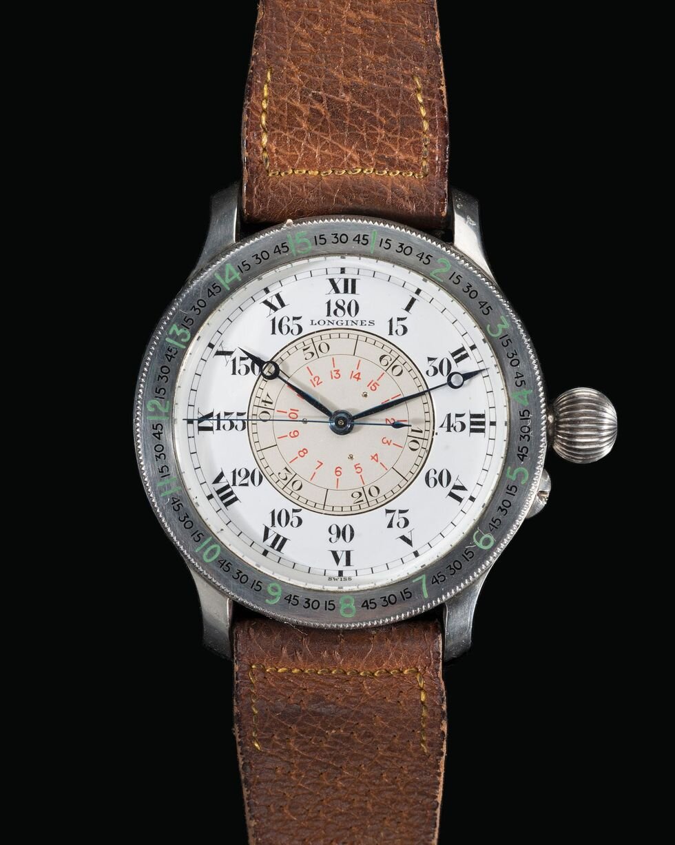
More precisely, every 4 hours, the minute hand tracks the world turning one degree, this is shown on the outer bezel. Every rotation of the seconds hand indicates a 15-minute arc, with a 1-minute arc being 1/60th of a degree. A 15-minute arc equals a quarter of a degree. So, you can be extremely precise with this measurement which is crucial for air navigation.
To determine the hour angle of civil time, move the reference mark of the bezel by negative three minutes to determine solar noon in Greenwich, this is indicated in the astronomical almanac.
An astronomical almanac is a book which is a worldwide resource for fundamental astronomical data. It contains precise positions of the sun, moon, and planets. It has all relevant information relating to Earth orientation, time-scales, and coordinate systems and would be used in navigation along with the Hour Angle watch.

Using the indications from the astronomical almanac, adjust the bezel / Credit: Longines
Now that the bezel is correctly positioned, you can measure the hour angle for civil time at noon.

Hour hand indicating 165 degrees, minute hand indicating 11 degrees, and second hand indicating 0 degrees / Credit: Longines
Therefore, the hour angle of the Greenwich meridian is 176 degrees (165+11+0). Now that the hour angle of the Greenwich meridian is defined (civil time), you must subtract the hour angle of the current position (true solar time). The sextant can also provide you a precise reading of the solar noon (true time) at your present location.
Since solar time doesn’t need to adjust for the equation of time, the watch’s rotating bezel can be returned to its initial neutral position. The display of solar noon now tells us the hour angle of the present location.

Showcasing the time of day without GMT reset using a sextant / Credit: Longines

Hour hand shows 135 degrees, minute hand shows 1 degree, and seconds hand shows 0 degrees / Credit: Longines
The hour angle of your present location would be 136 degrees (135+1+0). To determine the longitude of your present location, work out the difference between the two hour angles. If the longitude obtained is a positive number, that number is west of Greenwich. If the longitude is negative, it is east of Greenwich. With an original number of 176 degrees and 136 degrees for the present location, the equation of time or difference between the two would be a longitude of 40 degrees West.
So, the exact geographical location is 50 degrees North latitude (which was determined using the sextant), and 40 degrees West longitude.
While intricate and obviously not as simple as the technology of today, the Hour Angle is still a remarkable piece of technology for the 1930s and an early example of 20th century navigational developments. Charles Lindbergh’s design certainly worked in terms of providing one with their precise location, representing an era of watchmaking that is long lost in today’s culture of smart watches – self-sufficiency.
By: Eric Mulder
Read more:
“The Longines Lindbergh Hour Angle Watch.” Youtube, uploaded by Longines, November 14th, 2017, https://www.longines.com/universe/films/lindbergh90th.
“The Astronomical Almanac.” HM Nautical Almanac Office, http://astro.ukho.gov.uk/nao/publicat/asa.html.

A Longines Automatic Elegant Collection with box and papers for sale on Toronto Vintage Watches.